
Pelican Beach Resort 3D Explorer
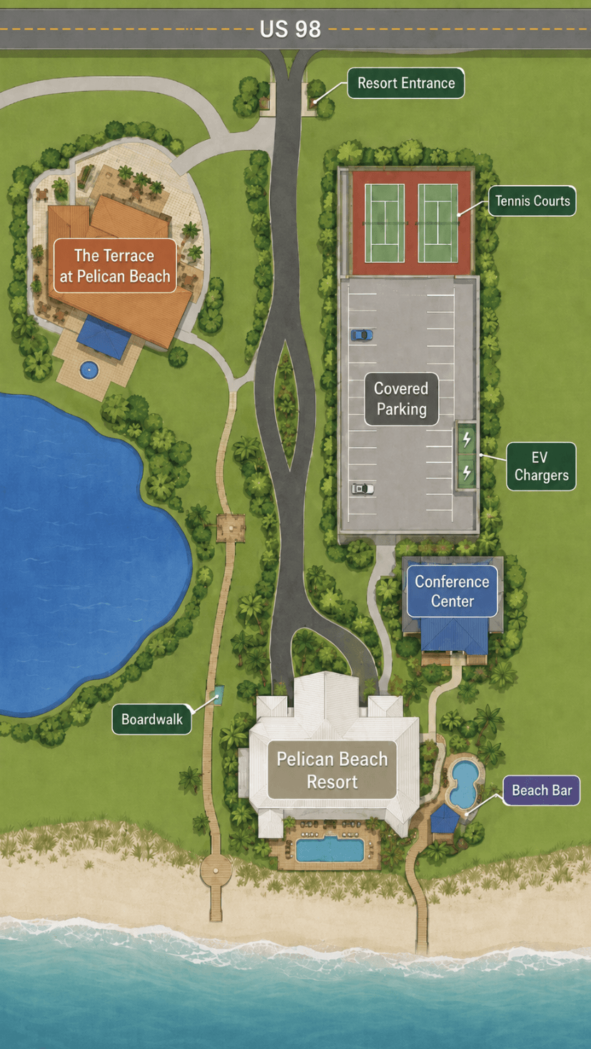
Explore the interactive map and understand arrival from US-98 to the Gulf.
Launch the 3D ExplorerRotate and zoom the resort, follow the visual arrival sequence, select named locations, and open real photographs of parking, pools, dining, recreation spaces and the route toward the Gulf.
MyPelicanBeach.com independently created this interactive 3D experience specifically for exploring Pelican Beach Resort before arrival.
Find your way from arrival to the Gulf
Rotate the property, choose a defined location, open its real photograph or play the guided arrival story.
US-98, resort entrance and parking
The north side introduces the entrance road, guest parking, garage and recreation courts.
The white L-shaped Gulf tower
The building geometry preserves the beachfront facade and deeper Pelican View wing relationship.
Pools, tiki deck, sand and Gulf
The south side leads through the pool decks and beach access to Destin’s white sand.
Conceptual orientation model—not a survey, evacuation map or accessibility-routing document. Amenity positions and proportions are approximate.
What the Pelican Beach Resort 3D Explorer does
A written guide can say the entrance is on the US-98 side and the beach is opposite the building. The Explorer shows how those places relate spatially. It combines a rotatable property model, arrival-story player, selectable named locations and real photographs.
See the property
Understand buildings, parking, amenity areas and the Gulf as one connected place.
Follow arrival
Move visually from US-98 and security toward the main guest areas.
Recognize locations
Connect simplified model positions with photographs of actual resort areas.
It does not provide door codes, live parking availability, operating hours or a substitute for private guest instructions.
Resort Explorer versus Condo Finder
| Tool | Main question | Focus |
|---|---|---|
| Resort 3D Explorer | How is the property organized, and where do I go? | Entrance, security, parking, lobby, pools, amenities, boardwalk and beach |
| 3D Condo Finder | Where is a condo inside the Gulf-front tower? | Floors, stacks, balconies, layout families and condo selection |
Use the Pelican Beach 3D Condo Finder when comparing condo positions or floors.
How to use the interactive map
Click and drag, or drag with one finger. Use Reset View if the angle becomes confusing.
Use a mouse wheel, trackpad, visible controls or a two-finger pinch.
Expand the experience for more room on laptops, tablets and phones.
Keep track of the US-98 and Gulf sides while the property rotates.
Choose a named location to move the camera and display its banner.
Tap or click defined areas; not every visible surface is interactive.
Pelican Beach Resort from US-98 to the Gulf
US-98→Security→Entrance→Parking→Building→Pools→Beach→Gulf
The road side contains the vehicle approach, security entrance, parking and principal arrival landmarks. The building zone connects the arrival side with the lobby and common areas. Beyond the building are the principal swimming and waterfront areas, followed by the designated beach route.
Read how the resort is organized from US-98 to the Gulf for the written explanation.
Follow the arrival story
Select Play Arrival Story to begin a guided camera sequence through a typical first arrival. Pause to inspect a location, resume, move backward or forward, or exit into free exploration.
- Recognize the entrance from US-98.
- Approach the security gate.
- Identify the main-building side.
- Understand temporary unloading orientation.
- Compare surface parking and the garage.
- Locate the lobby area.
- Move visually toward the pools and beach.
The story establishes a mental map; it does not reproduce a live drive or authorize access. Review the guest-logistics guide and follow the exact reservation instructions.
Arrival and parking directory
| Explorer location | What it explains | What to confirm |
|---|---|---|
| US-98 | Road side and general direction of approach | Current route, construction and correct entrance |
| Security gate | First property-access point | Information or credentials currently required |
| Main entrance | Principal arrival side of the main building | Entrance specified by current instructions |
| North lobby | Building-entry and orientation landmark | Door access and appropriate guest entrance |
| Temporary guest parking | Difference between unloading and regular parking | Permission, duration and restrictions |
| Open Parking 1 and 2 | Mapped surface-parking zones | Approved spaces, credentials and availability |
| Two-level parking garage | Garage position relative to the building | Clearance, permitted areas and availability |
| Accessible parking | Marked locations near the entrance and garage | Permit, availability and complete route suitability |
| EV charging | Charging position in the garage environment | Status, connector, payment and time limits |
Open Parking 1, Open Parking 2, North Lobby and Temporary Guest Parking are orientation labels. They do not promise availability, reserved spaces or permanent resort terminology.
Pools and waterfront directory
Dolphin Pool
Pool area associated with the Dolphin-fountain side
Dolphin hot tub
Spa location in the Dolphin pool zone
Kiddie pool
Shallower children’s area represented in the model
Gulf Pool
Newer Gulf-facing pool area
Gulf hot tub
Spa associated with the Gulf-side pool zone
Indoor and outdoor pool
Connected swimming areas near the building
Beach and Gulf
Final water-side orientation
Beach-chair rental
General beach-service destination near the boardwalk route
Operating conditions, heating, access, closures, beach service and equipment-placement procedures can change. Use the beach access and chair-rules guide.
Food, recreation and services
Separate mapped dining destinations; the map shows location, not live operating status.
Shared cooking-area orientation relative to the building and pools.
Wellness-facility locations whose access and operating status should be confirmed.
Courts shown in relationship to the garage and wider property.
For off-property choices, see where to eat and things to do near Pelican Beach Resort.
Desktop and mobile instructions
| Task | Desktop or laptop | Phone or tablet |
|---|---|---|
| Rotate | Click and drag | Drag with one finger |
| Zoom | Wheel, trackpad or visible controls | Pinch with two fingers |
| Select | Click a defined area or menu item | Tap a defined area or menu item |
| Photograph | Select the banner’s photo control | Tap the photo control |
| Arrival story | Use play, pause, back and forward | Use the same visible controls |
| Fullscreen | Select fullscreen | Select fullscreen; rotate device if helpful |
| Starting angle | Select Reset View or press Esc | Select Reset View |
On a phone, the Explorer may temporarily take control of gestures that would otherwise scroll the page. Close an open banner or use the page area outside the model to resume normal scrolling.
Accessibility and accuracy limitations
A mapped accessible space does not guarantee availability, vehicle fit, clear curbs or thresholds, elevator suitability, or an accessible pool, boardwalk and beach transition. Verify the complete route for the guest’s exact needs.
The model is independently created, illustrative and not to scale. It is not a survey, photogrammetric reconstruction, measurement tool, live parking display or substitute for posted signs. Small distances, angles, landscaping, structures and boundaries may be simplified for clarity.
Frequently asked questions
What is the Pelican Beach Resort 3D Explorer?
It is an independently created interactive property-orientation tool showing entrances, parking, pools, amenities, beach access and practical locations at Pelican Beach Resort.
Is this an official Pelican Beach Resort map?
No. MyPelicanBeach created it independently. It is not an official resort or owners’ association product.
Is the 3D Explorer the same as the Condo Finder?
No. The Resort 3D Explorer explains the property and arrival routes. The Condo Finder helps users compare condo floors, stacks and balcony positions.
Can I use the map to find the resort entrance?
Yes. The Explorer shows the relationship between US-98, the security gate and the main-building side. Follow current road signs and arrival instructions when driving.
Does it show where guests can unload?
The model includes a temporary guest-parking or unloading location for orientation. Current permission, time limits and procedures must be confirmed.
Does it show the parking garage and EV charging?
Yes. The Explorer shows the garage and charging area. It does not show live charger availability or guarantee that a space is open.
Can I see the route to the beach?
Yes. The model helps explain the transition from the main-building area through the Gulf-side amenities toward the beach.
Does the map show every pool?
It identifies the principal pool and hot-tub areas represented in the current model. Operating status and access should be checked separately.
Are the photographs current?
Photographs reflect the mapped locations but may become outdated after construction, renovation or operational changes.
Can the model confirm wheelchair accessibility?
No. It can help identify a route for discussion, but the complete route and exact guest needs must be verified directly.
Does the map show opening hours?
No permanent operating hours are embedded in the model. Use current resort information and posted notices.
Does the tool work on a phone?
Yes. The design supports mobile dragging, pinch-to-zoom, location selection, fullscreen and arrival-story controls. Performance can vary by device and browser.